
RESEPI Hesai XT32 Drone LiDAR Accuracy Case Study - Hard Surfaces
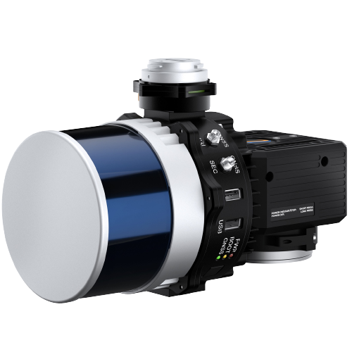
RESEPI is a combined GNSS-Aided Inertial Navigation System, datalogger, LiDAR, camera, and communications system that allows for the real-time and post-processed generation of point cloud solutions. What separates RESEPI is its best-in-class IMU accuracy, with roll/pitch accuracy of 0.006 and heading accuracy of 0.030. Combining this accuracy with the Hesai XT32 delivers a top of the line LiDAR that can be integrated with a number of drones, including the DJI M350 RTK.
In this series of case studies we will look at the accuracy of the data in different scenarios. In the first we will look at performance on hard surfaces. The Emlid Reach RS2+ was used as a base station on a known point, logging raw data for processing. The DJI M300 RTK carried the XT32, flying at an altitude of 165 ft and a speed of 11 mph. This results in about 2 acres of coverage per minute of flight.
PCMaster is used to create an LAS file from the raw data stored on the RESEPI and from the base station. No smoothing, noise reduction, or point cloud manipulation at all was performed. The strength of the RESEPI XT32 is in its ability to generate high quality results in their raw form. This results in the most consistent data as compared to using smoothing/noise reduction which can in some cases degrade, rather than improve the data.
Check shots were collected with the GeoMax Zoom95 robotic total station. When the check shots are imported they use the nearest LiDAR point and provide the elevation difference. It is automated, so there in no manual input of which points are being compared to each other.
First we will look at all the hard surface shots.

The RMSE on the 28 hard shots is 0.037 feet.
| LIDAR_ELEV | ELEVATION | ELEV_DIFF | ELEV_DIFF_ABS |
| 319.2807 m | 319.3121376 | -0.0315 m | 0.0315 m |
| 320.713 m | 320.6916624 | 0.0213 m | 0.0213 m |
| 319.2994 m | 319.2783048 | 0.0211 m | 0.0211 m |
| 319.2637 m | 319.2798288 | -0.0161 m | 0.0161 m |
| 319.7273 m | 319.7117304 | 0.0155 m | 0.0155 m |
| 319.3343 m | 319.34658 | -0.0123 m | 0.0123 m |
| 319.5202 m | 319.508124 | 0.0121 m | 0.0121 m |
| 319.3553 m | 319.3673064 | -0.012 m | 0.012 m |
| 319.6029 m | 319.5931632 | 0.0098 m | 0.0098 m |
| 320.6794 m | 320.6715456 | 0.0079 m | 0.0079 m |
| 320.6127 m | 320.6047944 | 0.0079 m | 0.0079 m |
| 319.3625 m | 319.3548096 | 0.0077 m | 0.0077 m |
| 319.3194 m | 319.3118328 | 0.0075 m | 0.0075 m |
| 319.2834 m | 319.2908016 | -0.0074 m | 0.0074 m |
| 320.545 m | 320.5377384 | 0.0072 m | 0.0072 m |
| 319.9235 m | 319.916556 | 0.007 m | 0.007 m |
| 320.5063 m | 320.4996384 | 0.0066 m | 0.0066 m |
| 319.3804 m | 319.3865088 | -0.0061 m | 0.0061 m |
| 319.3794 m | 319.3752312 | 0.0042 m | 0.0042 m |
| 319.2991 m | 319.3032984 | -0.0042 m | 0.0042 m |
| 320.1237 m | 320.1195528 | 0.0042 m | 0.0042 m |
| 320.2936 m | 320.2905456 | 0.0031 m | 0.0031 m |
| 320.4913 m | 320.494152 | -0.0029 m | 0.0029 m |
| 319.2922 m | 319.290192 | 0.002 m | 0.002 m |
| 319.5792 m | 319.5806664 | -0.0014953613 m | 0.0014953613 m |
| 319.6067 m | 319.6080984 | -0.0014343262 m | 0.0014343262 m |
| 319.3136 m | 319.3127472 | 0.0008544922 m | 0.0008544922 m |
| 319.5406 m | 319.5407376 | -0.0000915527 m | 0.0000915527 m |
If we look at the data closer, we can see that not all these hard surface shots are created equal. There are 12 shots on the catch basins, which could be more difficult than the other hard surfaces.
 |
 |
The RMSE of the catch basin shots is 0.044 feet.
| LIDAR_ELEV | ELEVATION | ELEV_DIFF | ELEV_DIFF_ABS |
| 319.2807 m | 319.3121376 | -0.0315 m | 0.0315 m |
| 319.2994 m | 319.2783048 | 0.0211 m | 0.0211 m |
| 319.2637 m | 319.2798288 | -0.0161 m | 0.0161 m |
| 319.3343 m | 319.34658 | -0.0123 m | 0.0123 m |
| 319.3553 m | 319.3673064 | -0.012 m | 0.012 m |
| 319.3625 m | 319.3548096 | 0.0077 m | 0.0077 m |
| 319.3194 m | 319.3118328 | 0.0075 m | 0.0075 m |
| 319.2834 m | 319.2908016 | -0.0074 m | 0.0074 m |
| 319.3794 m | 319.3752312 | 0.0042 m | 0.0042 m |
| 319.2991 m | 319.3032984 | -0.0042 m | 0.0042 m |
| 319.2922 m | 319.290192 | 0.002 m | 0.002 m |
| 319.3136 m | 319.3127472 | 0.0008544922 m | 0.0008544922 m |
Taking the catch basins out of the set and looking at the remaining hard surface shots we see an RMSE of 0.029 feet.
| LIDAR_ELEV | ELEVATION | ELEV_DIFF | ELEV_DIFF_ABS |
| 320.713 m | 320.6916624 | 0.0213 m | 0.0213 m |
| 319.7273 m | 319.7117304 | 0.0155 m | 0.0155 m |
| 319.5202 m | 319.508124 | 0.0121 m | 0.0121 m |
| 319.6029 m | 319.5931632 | 0.0098 m | 0.0098 m |
| 320.6794 m | 320.6715456 | 0.0079 m | 0.0079 m |
| 320.6127 m | 320.6047944 | 0.0079 m | 0.0079 m |
| 320.545 m | 320.5377384 | 0.0072 m | 0.0072 m |
| 319.9235 m | 319.916556 | 0.007 m | 0.007 m |
| 320.5063 m | 320.4996384 | 0.0066 m | 0.0066 m |
| 319.3804 m | 319.3865088 | -0.0061 m | 0.0061 m |
| 320.1237 m | 320.1195528 | 0.0042 m | 0.0042 m |
| 320.2936 m | 320.2905456 | 0.0031 m | 0.0031 m |
| 320.4913 m | 320.494152 | -0.0029 m | 0.0029 m |
| 319.5792 m | 319.5806664 | -0.0014953613 m | 0.0014953613 m |
| 319.6067 m | 319.6080984 | -0.0014343262 m | 0.0014343262 m |
| 319.5406 m | 319.5407376 | -0.0000915527 m | 0.0000915527 m |
If you would like to see the full data set or any sample data, request the hard surfaces data here.