
RTK GNSS Accuracy Test: Emlid Reach RS2 vs. Topcon Hiper VR
The intent of this study is to determine whether there are comparable accuracy results between the Emlid Reach RS2 and Topcon’s newest receiver, the Hiper VR. Jim Knuckey, PE, with 46 years of experience in surveying and construction (including 15 years in GPS and Machine Control) conducted this study.
Using RTK, the Reach RS2 with ReachView 3 and the Reach RS2 with FieldGenius for Android (both collected on the E38 Vivid Tablet), were on par with the Topcon Hiper VR running Pocket 3D on an FC500. All GNSS data was compared to data collected using a robotic total station. Table 1 displays the root mean square error for each receiver.
Table 1. Root Mean Square Error (ft)

Table 2. Difference (ft) between Hiper VR and Reach RS2

Setup
All data was collected in State Plane OH S. Both the Emlid Reach RS2 and the Hiper VR captured the same nine locations. The table below includes the brands, products, software, data collectors, and corrections used to complete this study.
Table 3. displays the instruments used to conduct this study

Locations
We define Ideal Locations as those with a clear view of the sky.
Somewhat Challenging Locations include satellite view obstructions and multipath.
Challenging Locations included significant satellite view obstruction and

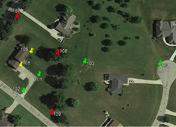
Figure 1 displays the locations of all shots using Google Earth
Results & Discussion
Table 4. displays the findings from all points in this study:

The Hiper VR collected shots at all nine locations. The elevations were leveled using 107 as the bench. The robotic total station was set up and a resection was performed using 103 and 107. The robot was then used to collect the remaining shots. The selection of 104 was done arbitrarily, and may have led to robot elevation data being skewed based on inaccuracy of the Hiper VR elevation on 104.
In the Ideal locations, all data showed negligible differences, though location 104 shows more error than usual. All three data sets on 104 are skewed in the same way, indicating there may be some human error involved.
In the Somewhat Challenging locations, the accuracies were generally exceptional. The elevations captured in ReachView 3 had noted deviations of 0.10 ft and 0.15 ft. While it is not quite as strong as other data points, it is not unusual to receive deviations such as this.
In the Challenging locations, all three data sets were strong overall, with each having an instance of notable elevation difference:
• ReachView 3 at 0.15 ft,
• FieldGenius for Android at 0.22 ft
• Hiper VR at 0.18 ft.
This is typical, given the conditions and imperfections of RTK GNSS receivers.
The elevation difference between OPUS and RTK was in the range of 0.20 ft. When processed with OPUS, the Hiper VR and Reach RS2 were nearly identical on point 2. It seems most likely that the OPUS data is more accurate. Contributing factors to this error may have been leveling using point 5 combined with typical RTK inaccuracies.
Conclusion
Based on this study, the Emlid Reach RS2 with Reachview 3 as well as with FieldGenius for Android, provide comparable accuracy to that of the Topcon Hiper VR across a variety of different environmental conditions in both RTK and when processed using OPUS.